Friday, March 9, 2012

Siwa Oasis and the Oracle of Amun


The Siwa Oasis is of course most famous for its association with Alexander the Great, whose exploits have been handed down to us through the writings of his biographers Arrian and Calisthenes. In 331 BC, after defeating two Persian armies at the battles of Granicus and Issus and marching on southward into Palestine, Alexander was able to 'liberate' Egypt from Achaemenid rule. Then, for a reason not fully explained by the Hellenistic historians, the young king of Macedon suddenly had a ‘strong desire’ (Greek pothos) to undertake the hazardous journey into the Western Desert to seek an audience with the Oracle of Zeus Ammon at Siwa. This was no easy undertaking, as, on a number of occasions, the desert had already claimed the lives of other travellers who had attempted to reach this remote island of green hidden in a vast arid sea of sand covering over 680,000 square kilometres. Only two centuries earlier, a great army of 50,000 men was sent by Cambyses to "attack the Ammonians [the priests of Amun], reduce them to slavery, and burn the Oracle of Zeus" [Herodotus Book III.26]. The Persian army had tried to reach Siwa from the south, via the oasis of Kharga, but was never seen again; all 50,000, to the last man, perished on that expedition and the equipment of those unfortunate soldiers still awaits discovery, somewhere out beyond the southern oases, lying petrified beneath the drifting sand.

Location

The Oasis of Siwa is located in the northern sector of the Western Sahara, immediately to the West of the Qattara Depresion and some 600 kilometres from the Nile Valley. The principal modern (and indeed ancient) communication route with this remote outpost is from Alexandria via Matruh (ancient Paraetorium) on the Mediterranean coast, then south across the desert. At this point the modern tarmac road gives way to an unmade track for 100 kilometres which finally reaches Siwa from the north. There are also three camel tracks leading out from Siwa: west to Girbah Oasis, north-east to Qarah Oasis and south-east to Bahriyya and from there to the other southern oases.

Siwa Oasis

The Oasis of Siwa itself is a very extensive shallow basin, being approximately 82 kilometres from east to west and 28 kilometres from north to south. Within this depression are seven large salt lakes, the greatest of which are Birket Siwa and Birket Zaytun. As well as these large areas of standing saline water, which are obviously useless for irrigation, there are a number of man-made artesian wells which provide more than sufficient fresh water to irrigate vast plantations of date-palms and fruit-trees.

Rising out of the greenery are a number of rocky outcrops on which, since time immemorial, the local population groups have built their fortified settlements, affording them protection against the more dangerous desert fauna and, in particular, nomad/Beduin raiders.

Siwa Oasis with Siwa Hill in the background

The modern inhabitants of Siwa are mainly of Medieval Berber descent, having arrived in the region in the early 13th century in a group one hundred or so strong. It is only in relatively recent times that they have relinquished their unusual Berber dialect for modern Arabic. The forty men and their families settled around a rocky cone, building a fortified stronghold which they called 'Shali' (Berber for 'town'). This was later to become 'Siwa', after the name of the particular Berber tribe who had founded the settlement, and now forms the heart of the modern village of that name. The pharaonic name for the oasis is not certain but what limited evidence there is suggests that it may have been called 'Thay' or 'Tha'.

The medieval village on Siwa Hill

The more ancient inhabitants of the oasis were settled on and around the rocky crag of Aghurmi, some four kilometres east of Siwa town, and they continued to reside within the walls of this mudbrick fortress until 1926 when a heavy thunderstorm (lasting three days) destroyed a large number of houses, killing their inhabitants. The population then departed from the site, which had been occupied since pharaonic times, and built a new settlement nearby. It was that exodus from the crag which enabled the archaeologists to begin the work of clearing the medieval occupation in order to gain access to the more ancient remains which had been identified by James Hamilton in 1853 but which were otherwise only known through the stories of Alexander's visit to the Oracle.

The Ancient Pharaonic Sites

There are a number of ancient sites within the Siwa depression and around its periphery, including Aghurmi, Umm Ubayda, Ayn el-Gubba, and Gebel el-Mawta. Of these the settlement atop the Aghurmi crag is certainly the most interesting because it was here that the Temple of the Oracle of Amun was rediscovered in the last century and where most of the subsequent excavation and survey work has been concentrated in recent years. Before turning to this site, which will form the basis of this discussion, we should perhaps first take a brief look at the other locations containing pharaonic remains.

Umm Ubayda

The site of Umm Ubayda includes what was once an impressive temple built by the 'the Great Chief of the Desert', Wenamun, for the pharaoh Nectanebo II (360-343 BC) of the 30th Dynasty and dedicated to Amun. The temple lies within the palm groves just half a kilometre to the south of Aghurmi.

Unfortunately, and not untypically, this fine monument was blown up by a local official, one Mahmud Azmi, in 1897 so that the blocks could be used to construct a new staircase for the local police station and, needless to say, one also for his own house. What remains today is the stump of a wall from the sanctuary which never the less is richly decorated with scenes of Wenamun, Libyan feather in hair, kneeling before Amun and with a procession of deities behind him. The two temples of Aghurmi and Umm Ubayda are connected by a ceremonial way and probably functioned under a single administration, given the isolation of their setting.

Alexander's biographers mention a second temple of Amun, other than the Temple of the Oracle, and describe its setting amidst the palm groves of the oasis; this is no doubt the temple at Umm Ubayda.

Ayn el-Gubba

Ayn el-Gubba is the famous 'Spring' or 'Fountain of the Sun' to which Herodotus accords miraculous powers: he tells us that whilst during the hot hours of daylight its waters remain cool and refreshing, at night, however, the spring "boils furiously" [Herodotus Book IV.182]. In fact, the bubbling effect is caused by natural gasses rising from rocks beneath the surface – the temperature, of course, remains much the same throughout the 24-hour day.

Gebel el-Mawta

The limestone cliffs of Gebel el-Mawta, a promontory rising out of the palm groves in the northern sector of the fertile basin some five kilometres north of Aghurmi, formed the principal burial ground of the ancient Siwan settlement. Indeed, Gebel el-Mawta means 'The Hill of the Dead' in Arabic and is also called Qaret el-Missabbarin – 'The Ridge of the Mummified'. There are a great number of tombs in the area, many of which are now completely buried in sand. A number of others will have remained undiscovered, since a systematic excavation of the site remains to be undertaken. The important published tombs are those of Niperpathoth, Mesuisis, Siamun and the so-called 'tomb of the crocodile'.

The most interesting is that of Siamun which has fine colourful scenes of the deceased and his family painted on plastered walls. There is little doubt that, in spite of his Egyptian name, Siamun was not of Egyptian stock as he is shown with pale complexion, beard and thick black curly hair. His wife is darker skinned and bears the good Egyptian name Neferheret – 'beautiful of face'; she most probably, therefore, was a native Egyptian. Siamun's father, with the name Periytu, is, however, undoubtedly of foreign extraction. As if to add further confusion, the son of the tomb owner is depicted in Greek dress whilst Siamun himself wears the clothes of an Egyptian nobleman. Thus the tomb of Siamun is strong evidence for the international character of Siwa during the Hellenistic Period and appears to demonstrate that intermarriage was practiced between the Greek world and Egypt.

Aghurmi

We now turn to the most important of the Siwan sites, that of the Temple of the Oracle itself. The pharaonic remains are located on the relatively flat-topped rock of Aghurmi which forms a natural acropolis rising to some thirty metres above the palm groves. It appears that, not long after the temple and ancillary buildings fell into disuse, the rock was occupied by the local inhabitants who moved from the vulnerable low-lying areas into the fortified citadel of the Siwan chieftains – the local governors of the pharaohs. As a result, when the temple was discovered in modern times it was sheathed in mudbrick houses with very little of the ancient structure visible.

The major task of clearing the temple of its Medieval overcoat was undertaken by Ahmed Fakhry in 1970 but before that three brief surveys had been completed, first in 1932, by Ricke, Steindorff and Aubin, and then in 1938 and 1941 by Fakhry himself. More recently, during three seasons of activity at Siwa, a much fuller investigation of the temple and its surroundings was conducted by the German Archaeological Institute in Cairo under the direction of Klaus Kuhlmann. This work has revealed some very interesting details about the workings of the Oracle and its temple which had not been hitherto noted and these findings will be dealt with at the end of this section on the temple at Aghurmi.

During the two days that Ricke and his colleagues spent at Aghurmi they attempted to establish the building date of the Temple of the Oracle and indeed Steindorff, whose assignment was the investigation of the 'Holy of Holies' or 'cella', did locate a much damaged cartouche which he read as that of Achoris (393-381 BC), third king of the 29th Dynasty. Thus the earliest known building activity at the site – the sanctuary itself – could be taken back only as far as the post-Persian era. This was obviously very disappointing, as it cast doubt on the veracity of Herodotus' story about Cambyses' attempted assault on the Oracle. Then, in 1938 Fakhry cleaned down the inner walls of the cella and was able to show that the builder of the temple was in fact Amasis (570-526 BC) the last ruler of the 26th Dynasty, just prior to Cambyses' invasion. Thus Herodotus was vindicated by modern archaeology for now there was proof of the existence of the Oracle in late-Saite times.

The Temple of the Oracle

Let us now take a more detailed look at the Temple of the Oracle to learn something of the way it was built and how it may have functioned, at the same time recalling the Alexander-narrative so as to determine the accuracy of the Hellenistic descriptions.

At first glance it appears that the temple is of the basic Late Period/Pre-Ptolemaic Egyptian design, consisting of a courtyard and gateway with an interrupted lintel leading to an open portico/hall, a second inner hall and finally the central sanctuary with chambers on either side. However, when one looks further, there are a number of very untypical aspects in terms of both the temple's location and its design.

The Temple of the Oracle of Amun on Aghurmi Hill

Firstly, and perhaps most obviously, the temple is located on top of a rocky crag. Throughout the whole corpus of temple or shrine building activity in ancient Egypt this is almost, but not quite, an exceptional occurrence. Only four other examples come to mind, the last two of which are even then somewhat doubtful. The obvious and most clear cut example is the shrine of Thoth built by Saankhkare Mentuhotep (2010-1998) of the 11th Dynasty which is located atop the highest peak in the hills of Western Thebes. Secondly, there is the Ptolemaic temple of Petesuchos at Karanis in the Faiyum – not only later than the Siwan temples but perhaps also the closest in character to the Temple of the Oracle. Then we may tentatively add the 'high place' at el-Hiba, which, although probably a sacred altar of some kind, now has insufficient remains to indicate if there was ever a mudbrick building at the site. Finally there is the Predynastic temple/shrine of Horus at Hierakonpolis which appears to have been erected on top of a large platform. All the other temples of dynastic Egypt (apart from the rock-cut speoses), as far as I am aware, were built on low-lying ground. In this respect therefore the Aghurmi temple is most unusual.

Furthermore the temple was reached by a grand stairway leading up from the base of the rock where the sacred well was located (mentioned by the Greek historians). This is only paralleled at Karanis but, even then, on a much smaller scale.

At the head of the stairway there was a narrow terrace in front of the entrance to the court. This court may have been that described in Alexander's story where the barque of the Oracle was paraded around the king and his escort before Alexander went alone into the shrine for his private audience. Above the low wall, on either side of the main entrance gateway, a second facade had been erected in Greek times, perhaps at the behest of Alexander himself. Attached to this second wall, and standing on the cavetto-cornice of the earlier 26th-Dynasty facade, were two fluted half-columns. The facade was otherwise completely plain and without inscription.

Now we come to perhaps the most intriguing features of the temple, the ones which give it its special character as the seat of one of the most famous oracles of the ancient world.

The cella, or shrine of the Oracle, possessed a number of special features which enabled the priests to put on dramatic performances for those wishing to seek the wisdom of the Oracle. Firstly, the cella had a second storey, which had no visible entrance, from where a priest could secrete himself and deliver the words of the ram-headed statue of Amun. Thus the source of the voice of the Oracle remained heard but unseen by those who had been granted a private audience – as in Alexander's case. The Oracle's theatrical performance could be further enhanced by other priests shaking sistra, making noises, or playing the roles of the other gods. This was done by means of another secret corridor located behind and to the right of the statue. Thus the voices of the priests could be made to resonate through the walls of the shrine echoing in the darkness all around the statue of Amun, bedecked in jewels – the ancient equivalent of a Son-et-Lumiere performance at Karnak perhaps? This corridor was only accessible via an ingenious tunnel, the entrance to which was only recently found at the base of a cliff immediately to the rear of the temple on the northern edge of the acropolis. By this elaborate system of hidden rooms and corridors the priests were able to impress even the least impressionable of visitors, and it is not really surprising that the Oracle of Zeus-Ammon was so renowned during the Greco-Roman era when exotic cults and mystic religions became so popular.

What we do learn from this, however, again leads us to think how un-Egyptian the temple and its Oracle were by the time Alexander made his visit. It is reasonably clear, from the archaeological remains of the pre-Ptolemaic temples of Egypt, that the Egyptian clergy did not go in for elaborate deceptions – in particular ones which involved the performance of the god's spoken word. We know this because no hidden chambers have been found earlier than that at Siwa. It is only in the Greco-Roman temples such as Dendera, Edfu and Karanis that such devices are introduced to deliver the oracular messages. We further observe that the normal method of oracular delivery in true Egyptian style was the silent nodding of the sacred barque of the oracle as it was brought before the questioner. This ceremony was usually performed not inside the holy shrine but outside in the public gaze. Indeed, as we have noted, this is precisely what happened when Alexander and his men were first introduced to the Oracle in the forecourt of the temple, before the king was given his private audience in the inner sanctum where he learnt of his divine parentage.

It thus appears that the oracular voice was a Greek invention and that the building of the Aghurmi temple, late in the 26th Dynasty, may have been a partially Greek affair, undertaken by an expeditionary force of Greek mercenaries sent by Amasis to garrison the Oasis. The involvement of the local native ruler of the Siwa Oasis, a Libyan named Sutekhirdes 'Chief of the Desert Dwellers', is quite evident as it is his figure which occupies one of the inner walls of the shrine, offering to the gods, whilst the king is portrayed on the opposite wall in a similar fashion.


Summary

Although Alexander's experiences at Siwa are the only written records that we can draw upon to learn something of the history and nature of the place, modern excavations and surveys have revealed further information which not only confirms the accounts of Callisthenes and Arrian but also appears to show that Siwa only came under Egyptian control in the Late Period.

The earliest pharaoh recorded at the Oasis is Amasis and none of the other buildings, including the outlying temples of Bilad el-Rum, Qasr el-Ghashsham, Abu Sharuf and el-Zaytun (not discussed in this essay), are earlier than 360 BC. Indeed all are of Greek or Roman date.

The local chiefs or governors whose images appear on the Aghurmi and Umm Ubayda temples, along with Amasis and Nectanebo, do appear to be of Libyan stock and one must presume that contact was made between Egypt and Siwa certainly by the 22nd Dynasty. Siwa may have in fact been one of the primary staging points in the Libyan migrations of the early Third Intermediate Period.

With Old Kingdom mastabas having been found at Dakhla, we know that the Southern Oases were under Egyptian influence for most of the period of dynastic rule, but no such evidence exists for Siwa. Acknowledging that the following assumption is based on negative evidence, nevertheless I have to conclude that the Oasis of Siwa was essentially a foreign land and not a part of Egypt until the area was brought under pharaonic control in the late-26th Dynasty of the Saites. Subsequent archaeological investigation may invalidate this statement, however, for the moment, this conclusion, having been founded on what the site has revealed to date, appears to be justified.


Bibliography

C. D. Belgrave: Siwa: The Oasis of Jupiter Ammon (London, 1923).

A. Fakhry: Siwa Oasis: Its History and Antiquities (Cairo, 1944).

--- 'Recent Excavations at the Temple of the Oracle at Siwa Oasis' in Agyptischen Bauforschung und Altertumskunde, Vol. 12 (Wiesbaden, 1971), pp. 17-33.

--- The Oases of Egypt, Vol. 1 (Siwa Oasis), (Cairo,1973).

K. P. Kuhlmann: Das Ammoneion: Archaologie, Geschichte und Kultrpraxis des Orakels von Siwa (Mainz an Rhein, 1988).

W. J. Murnane: The Penguin Guide to Ancient Egypt (London, 1983).

G. Steindorff: Durch die Libysche Wuste zur Amonsoase (Leipzig, 1904).

Wednesday, February 29, 2012

Picture Gallery for February 2012

Here are some beautiful photographs of the Egypt you don't often see, taken by my good friend and exceptional photographer, Mike Shepherd. Enjoy!

The Mother of Pots (Umm el-Gaab, Abydos).

Felucca on the Nile.

The White Desert.

Philae Island.

Gweeta.

Fishermen on the Nile.

Dush.

If you want to see more of Mike's wonderful pictures, you can visit his web site at:

http://www.mikeshepherdimages.com


Tuesday, February 21, 2012

Online With Andrea Interview on Egypt and the Bible


Here is the archive file of the interview I did with Andrea Garrison on 20th February 2012 dealing with my research into the chronology of ancient Egypt and the implications of that research for Biblical history and archaeology. It's more than two hours long, so grab a cuppa and make yourself comfy when you have a spare time-slot, and see if any of it makes any sense to you. Then why not add a comment to let me know what you think.

http://www.blogtalkradio.com/onlinewithandrea/2012/02/20/biblical-truths-revealed-by-david-rohl

Enjoy!


Tuesday, February 7, 2012

The Road to Paradise


The snow-covered dome of the Mountain of God, shrouded in billowing clouds, towered above the old Mongol village known locally as 'the honeycomb'. Earlier that morning I had set out on a pilgrimage to the Exalted Throne of Yahweh where Adam's god dwelt. Within an hour the noise and chaos of Tabriz had been left far behind, as our four-wheel drive ascended out of the alpine valley of the Adji Chay onto the plateau of the Sahand massif, with imposing volcano at its heart. Now I found myself at the entrance to one of our world's most extraordinary places – the troglodyte village of Kandovan.

Ambling down the cobbled street – only just wide enough to take a donkey and cart – I turned up a steep side alley, all the time stalked by a clutch of free-roaming chickens. The alley soon morphed into a roughly sculpted flight of steps which twisted and turned between huge canine teeth of lava. Each was a home – a dwelling from a bygone age with rickety wooden door and tiny mullioned windows. In this Disneyesque landscape of cave-dwellers, I almost expected Pinocchio to appear around the next bend.

Kandovan.

My long journey, starting in the research libraries of London University, had led me to the Mesopotamian flood plain and on up into the mountains of Kurdistan, finally to reach the place the Book of Genesis calls the Garden of Eden.

There is no straightforward way to explain how an Egyptologist, used to working in the dry heat of the north African deserts, should end up traversing the Zagros mountains of western Iran in search of the Earthly paradise. I had begun my studies in the Departments of Egyptology and Ancient History at University College, London, with a major interest in the complex chronology of Egyptian civilisation. My PhD work to radically revise that chronology had inevitably drawn me into the world of Biblical history – so closely bound up with the land of the pharaohs. Years of research had led me to the conclusion that many of the stories in the Old Testament were based on real historical events: the Israelite sojourn in Egypt, the Exodus, the conquest of the Promised Land – all were attestable within the archaeological record once the correct chronology had been applied.

But why was I now delving into the Book of Genesis – that most mythological and hoary of the Biblical texts? Surely it would have been better to leave well alone? But that is not my way. The simple fact is that ancient stories and legends have always fascinated me, and the chance to uncover the historical reality behind the greatest legend of them all was just too tempting an opportunity to pass by.

Back in 1987 I had been sent a short, privately published paper by amateur historian, Reginald Walker (1917-1989), which proposed a location for the Garden of Eden in north-western Iran. The main thrust of Walker's argument was that the four rivers of Eden, described in Chapter Two of Genesis, were to be found in that region. All four had their sources (the Bible refers to them as 'heads') around the two great salt lakes of Van and Urmia.

Ever since the time of the Jewish historian Josephus, a near contemporary of Christ, scholars have tried to use Genesis 2 to locate Eden. But the problem has always been the identification of the rivers themselves. The Bible calls them Perath, Hiddekel, Gihon and Pishon. The first two are no problem: the Perath is simply the Hebrew version of Arabic Firat and Greek Euphrates; similarly the Hiddekel is Hebrew for Sumerian Idiglat from which the Greek Tigris derives. The remaining two rivers, however, have always been a mystery. Clearly, in order to locate Eden precisely, we need to find the sources of all four – and that's where Walker's research comes in.

The Zagros mountains.

He showed that the River Aras, flowing into the Caspian Sea from the mountains north of Lake Urmia, was once called the Gaihun. By checking the writings of the Islamic geographers who accompanied the Arabic invasion of Persia in the 8th century, I was able to confirm that this was indeed the case. Moreover, even as late as the last century, Victorian atlases and encyclopaedias were still naming the river as the Gaihun-Aras. The Gaihun is therefore the missing Biblical Gihon.

The fourth river – the Pishon – was more difficult to find. Walker suggested that this Hebrew (West Semitic) name derived from the old Iranian Uizhun, where the Iranian vowel 'U' had been converted into the Semitic labial consonant 'P'. Thus we have Uizhun to Pizhun to Pishon. Strange as it may seem, such switches do occur between the two language groups. For instance, one archaeological site in Iran is known by its Arabic (West Semitic) name of Pisdeli whereas its ancient (Iranian) name was Uishteri. The river Uizhun (the modern Qezel Uzun) – thus identified as the Biblical Pishon – flows down from the mountains of Kurdistan and empties into the southern basin of the Caspian Sea.

Bringing all this together we find that the sources of all four rivers originate in the highland area which Alexander the Great knew as Armenia and we know today as eastern Turkey and western Iran.

******

An extra-Biblical Sumerian epic known as 'Enmerkar and the Lord of Aratta' relates the tale of a journey made by the envoy of Enmerkar, King of Uruk, from his home city in southern Mesopotamia, through the seven high passes of the Zagros range and down into the magical kingdom of Aratta – the 'Eldorado' of the ancient world. Enmerkar was the second ruler of Uruk after the Flood, according to the Sumerian King List. A crucial line in the epic describes the envoy descending from the last of the seven mountain passes (the Sumerians called them 'gates') and crossing a broad plain before arriving at the city of Aratta with its red-painted city wall.

“The envoy, journeying to Aratta, covered his feet with the dust of the road and stirred up the pebbles of the mountains. … Five gates, six gates, seven gates he traversed. … Like a huge serpent prowling about in the plain, he was unopposed. … He lifted up his eyes as he approached Aratta”. [extracts from 'Enmerkar and the Lord of Aratta']

Here, the Sumerian word for 'plain' is edin which some scholars believe is the source of the word Eden in Genesis.

The Edin in spring.

So, combining Walker's discovery of the four rivers together with the Sumerian location of Eden, it seemed as though the whereabouts of the lost Eden and its fabled garden was near to being resolved. I decided to set out for the ancient city of Susa (burial place of Daniel of the lions' den) in the south-western flood plain of Iran (Iraq was off bounds for obvious reasons) from where I determined to retrace the Sumerian envoy's route to paradise.

Following the ancient track through the seven 'gates', I eventually reached the Miyandoab plain to the south of Lake Urmia. The journey had taken four days by car but would have taken the envoy the best part of four months by donkey. The edin remains today one of the lushest regions of the Middle East: thick soil, fruit orchards and vineyards, lazy meandering rivers. This, I am sure, was the original heart of Eden which, over time, became a much wider area, including both the salt lakes and the Garden of Eden itself. The Bible describes the latter as being 'east in Eden' – in other words to the east of but still within the wider territory of Eden.

The great salt lake of Urmia.

My driver and I continued eastwards, between the south-eastern shore of Lake Urmia and the towering volcanic peak of Mount Sahand. An hour's drive along the highway brought us into a long west to east valley, the slopes of which were terraced with 'every kind of tree' smothered in spring blossom.

“God planted a garden in Eden, which is in the east, and there he put the man he had fashioned. From the soil, God caused to grow every kind of tree, enticing to look at and good to eat”. [Genesis 2:8-9]

All around a high snow-laden ring enclosed the valley, nurturing its warm micro-climate. The nearest mountain to the north glowed bright red in the low evening light – a pile of pure red ochre. At its foot sprawled the regional capital of Tabriz, squatting at the centre of the valley where Adam and Eve (whoever they were) once lived according to Biblical tradition. The first thing that came to mind was paradise lost. Nothing of the Earthly garden and its settlement could have survived beneath these bustling streets. But then, away from the city, I soon discovered that there was much that remains of Adam's Neolithic culture.

Stairway to heaven.

This was the region where Man first began to settle down to sedentary life; where he learnt to domesticate animals and plant his crops; and where he began to bury his dead in graves, the bones painted in red-ochre. Adam's name means the 'red-earth' man. According to Sumerian mythology, Man was crafted by the gods from the clay of the earth, just as a potter throws his red clay pots on the wheel. The creation of Man in Genesis is much the same.

“Yahweh God shaped Man (Heb. Adam) from the dust (Heb. aphar) of the earth (Heb. adamah) and blew the breath of life into his nostrils, and Man became a living being.” [Genesis 2:7]

“… return to the earth (Heb. adamah), as you were taken from it. For dust (Heb. aphar) you are and to dust (Heb. aphar) you shall return.” [Genesis 3:19]

The red earth of Eden.

Here the word 'dust' is a poetical translation. The understanding of Hebrew aphar is the earth from which clay is made, or simply clay itself, and I believe the clay which gave Adam his name was sourced in the red mountain looking down on Tabriz. Throughout many prehistoric cultures (and including the later Mesoamerican civilisations such as the Maya) the daubing of human bones in red paint or powder was a substitute for the life-blood which had been lost with the decaying flesh.

******

The Hebrew word for 'garden' used in Garden of Eden is gan which has the meaning 'walled' or 'enclosed garden'. The enclosed valley of the Adji Chay is just that – a rich-soiled paradisiacal haven protected by high mountain walls. The Greek version of the Old Testament calls the Garden of Eden 'Paradise' (paradeisos) after the ancient Persian pairidaeza meaning 'enclosed parkland'. The great Meidans (royal squares) of Islamic Persia, particularly the beautiful Meidan-é Imam of Isfahan, are symbolic representations of the original Garden of Eden with their high enclosures and formal gardens containing fountains and pools.

When the descendants of the Mongol chieftains who had invaded Persia in the 13th century moved on into India to become the Mogul emperors of the 16th to 19th centuries, they took the Persian ideas relating to the Garden of Eden with them. So it was that Shah Jehan built the Taj Mahal for his beloved queen, Muntaz Mahal, not simply as a mausoleum but as a representation of heaven itself – with the mausoleum functioning as the Throne of God. Jehan was effectively recreating the paradise on earth which had been lost to humanity following the expulsion of Adam and Eve from the Garden of Eden. A study of the Koranic inscriptions around the arches of the Taj, undertaken by Professor Wayne E. Begley of Iowa University, has shown that this was the hidden secret of the building – the sacred knowledge of Eden brought out of Sufic Iran.

However, now that the landscape of Eden and its garden have finally been identified, I believe we are in a position to read much more into this extraordinary 17th-century monument to one man's vanity.

“I shall scale the heavens. Higher than the stars of God I shall set my throne. I shall sit on the Mountain of the Assembly far away to the north. I shall climb high above the clouds; I shall rival the Most High”. [Isaiah 14:13-14]

The Taj Mahal's glistening white dome, can be seen as a representation of the snow-capped Mount Sahand – the original exalted throne of God. The formal gardens in front of the Taj mirror the garden of paradise with the central pool (representing Lake Urmia) and the four water channels (representing the four rivers of Eden) flowing out from the centre of the complex. The ornamental arch leading into the enclosed garden of the Taj Mahal represents the mountain pass or 'gate' leading into Eden which was ferociously guarded by the cherubim and the Fiery Flashing Sword. The symbolism is striking.

******

But, back in the real Garden of Eden, we still have much more to discover. Even further to the east of the Adji Chay valley and Tabriz, beyond a high pass leading out of the Garden of Eden, is the land of Nod into which Cain was exiled after he had murdered his brother Abel. The area is still today called Upper and Lower Noqdi and many villages bear the epithet Noqdi ('belonging to Nod').

The life of Abel.

In the same region we find the town of Kheruabad. The name means 'settlement of the Kheru-people' and the Kheru were the Kerubim (Cherubs) of Genesis who protected the eastern entrance into Eden. The volcanic peak which guards the eastern gateway back into the Garden of Eden is a good candidate for the 'Fiery Flashing Sword' associated with the Kerubim. When I travelled over the pass beneath Savalan volcano for the first time, the vehicle was pounded by a violent electrical storm. To the ancients, used to the metaphor of jagged peaks as divine swords or spears, it would have been easy to envisage the angry mountain, casting down its bolts of lightening, as the Fiery Flashing Sword of Genesis.

I returned to Eden from Nod by a different route, travelling along the valley of the Ahar Chay – the next river basin north of the Adji Chay. The Ahar Chay is a major tributary of the Gaihun-Aras/Gihon which, according to Genesis 2 'winds all through the land of Cush'. My map confirmed once more that we really were in the primordial landscape of Adam and Eve. Separating the Ahar and Adji valleys, and acting as the northern wall of the Garden of Eden, stretched a high snow-capped ridge named Kusheh Dagh – the 'Mountain of Cush'.

Long after nightfall I was back in my Tabriz Intercontinental Hotel bed, dreaming of an early morning climb up to the Mountain of God.

******

Kandovan village beyond the trees.

The troglodyte village of Kandovan seems as old as the mountain to which it clings. We can certainly record its history back to the Mongol invasion of Persia in the 13th century when a group of settlers occupied the village. But none of today's locals have memories beyond the arrival of their Asiatic ancestors. Did the village exist before that time? It seems highly likely, given the complex agricultural terracing which covers the steep-sided valleys around the holy mountain. Assyrian war annals of the 8th century BC mention towns in the vicinity of Mount Uash (the Assyrian name for Sahand volcano) and these population centres would have required considerable agricultural produce which must have been eked out of the volcanic soil clinging to the slopes of Sahand. Beyond the 8th century BC we cannot go with any certainty, but Neolithic occupation around Lake Urmia and Mount Sahand has been confirmed by limited archaeological investigations. Of the thousands of ancient occupation mounds surveyed in this region only a tiny percentage have been excavated. We have just begun to scratch the surface in the land where human civilisation began.

Residents of Kandovan.

Whatever the ancient history of Kandovan, the soul of the place is timeless. Hardly anything has changed over the centuries – until very recently, that is, when electricity was piped up from Tabriz. The only other concession to the modern world is a tobacconist and a picnic area for Tabrizi weekend tourists. They come up the mountain armed with plastic containers to collect the water which flows down from the nearby summit of the mountain. This water is regarded as having magical properties: it cures the sick and prolongs life. Many a grandma or grandpa in Tabriz are fed the holy water of Mount Sahand to keep them fit and strong. The reason for this veneration is all to do with the sacred source of the river which runs through the Garden of Eden.

The waters of Eden.

At the summit of one of the two peaks of Sahand the extinct volcanic chimney overflows with ice-cool water as if from a bottomless well. The locals call it Jam Daghi – 'Mountain of the Chalice'. The water which gurgles from the tiny lake joins other streams, flows past Kandovan and on down into the Adji Chay valley, eventually forming a marshy delta on the eastern shore of Lake Urmia.

“A river flowed from Eden to water the garden, and from there it divided to make four streams (Hebrew roshim meaning 'heads')”. [Genesis 2:10]

In Sumerian theology spring-water lakes on top of mountains were regarded as holy places where humans might communicate with the great god of the underworld ocean of sweet water upon which the earth floated. Such an interface between the worlds of the living and dead was called an abzu, from which we get our word abyss. The god of the abzu was known to the Sumerians as Enki ('Lord of the Earth') – the creator of humankind and the 'friend of Man'. The Akkadians and Babylonians knew him as Ea (pronounced Éya) and it was this Ea who warned the Mesopotamian hero of the flood of the impending destruction of mankind by the storm-god, Elil (Sumerian Enlil). Could Ea, god of the Sahand abyss, have been the deity worshipped by Adam and Noah? You will have to wait for another day for the story of the flood when I will reveal the hidden name borne by the god of the Israelite ancestors.

Enki – God of the Spring Water.

Meanwhile, the troglodyte village of Kandovan, with its volcanic spires, was as close as I could get to Adam's world. I had travelled over one thousand kilometres from the Mesopotamian plain to the Garden of God. I had crossed seven mountain ridges, through the ancient lands of Kuzestan, Luristan and Kurdistan. I had followed in the footsteps of Enmerkar's weary envoy as he crossed over into the mysterious land of Aratta and, beyond, I had found myself in the primeval world of Adam and Eve. I was literally in Seventh Heaven. My journey had come to an end just below the summit of God's holy mountain. The Exalted Throne of God was within reach, a thousand metres above me, but sadly not this time. Dark clouds had enveloped the mountain and falling snow began to shroud the way forward. My meeting with God would have to wait for another time. I headed down the mountain, leaving Pinocchio and his friends to their own devices.

“Son of Man, raise a lament … You were in Eden, in the Garden of God … I made you a living creature with outstretched wings, as guardian, you were upon the holy Mountain of God, you walked in the midst of red-hot coals. … I have cast you down from the Mountain of God and destroyed you, guardian winged creature, amid the coals”. [Ezekiel 28:11-19]

The Temptation Seal (British Museum).

Friday, February 3, 2012

Secrets of the Desert


The Nile valley in Egypt is a thin thread of fertility in an otherwise parched and desolate landscape. As a result, virtually all archaeological work in the last 200 years has been concentrated in the valley itself or along its edges where the pyramids and tombs are located. Little attention has been paid to the desert regions which constitute ninety per cent of modern Egypt.

We are all familiar with the jewels of Egyptian civilisation – the Pyramids of Giza, the Temples of Karnak and the Valley of the Kings with its golden treasure of Tutankhamun. But few of these splendours tell us much about the beginnings of Egyptian history.

The origins of pharaonic civilisation have always been shrouded in mystery. At its beginning there are no signs of the gradual development of metal-working, art, monumental architecture and writing – the defining criteria of early civilisation. It is almost as if the pharaohs and their complex culture came into existence overnight.

So what was the mysterious and sudden inspiration at the heart of the origins of Egyptian civilisation? The answer is to be found in the Eastern Desert which separates the Nile valley from the Red Sea. There, in the rugged sandstone mountains, remarkable clues have been found to suggest that newcomers arrived in Egypt towards the end of the fourth millennium BC – a couple of centuries before the foundation of the pharaonic state. These clues come in the form of hundreds of prehistoric rock drawings. They depict high-prowed reed ships and their crews. Warriors are shown dragging their vessels through the desert from the shore of the Red Sea towards the Nile valley. Some of the boats carry as many as seventy-five crewmen. These were not small river craft, but huge ocean-going battleships.

It appears that Egypt was invaded by seafarers from a distant land to the east, and it was these foreigners who were the crucial cultural and technological influence which triggered early civilisation in north-east Africa. I decided to mount a series of expeditions to relocate and record these amazing images from Egypt's most ancient past, which had last been seen over sixty years ago.

Heading off into the desert.

Expeditions into the Eastern Desert are difficult operations. They have to be completed in a very short time because essential supplies are soon used up. In these brief bursts of activity we have to be highly mobile, and the desert is only safe in late November through to early February when the snakes and scorpions are tucked up in their holes hibernating through the short winter.

Between January 1997 and December 1998 I had already undertaken three sorties into the uncharted mountains of the Eastern Desert. With an ever-growing team of recorders and back-up personnel, we had gradually mapped, surveyed and photographed over fifty prehistoric sites.

This time I had come with an expeditionary force of twenty-six, made up of volunteer recorders from the Sussex Egyptology Society, a team of experienced Egyptian drivers and a pair of talented beduin cooks. We were crammed into five Toyota Land Cruisers, roofs piled high with tents, food rations and those two most vital commodities - water and fuel.

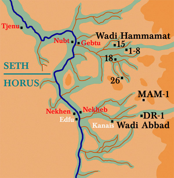
Wadis of Upper Egypt with the main rock-art sites marked.

We set off from Edfu on 20th January, heading east along the desert road to Mersa Alam on the Red Sea coast. Just beyond the little rock-cut temple of Pharaoh Seti I at Kanais we struck north-east into the wide mouth of the Wadi Abu Ashayir el-Atshan. Our convoy hurtled along, billowing clouds of dust in its wake. Within an hour we were deep into the complex wadi system which would be our home for the next five days. In prehistoric times these wadis were seasonal streams affording oases of shady refuge and life-giving water in an otherwise inhospitable environment.


The temple of Kanais in the Wadi Abbad.

Over the last 5,000 years the mountains of the Eastern Desert have become desiccated and the wells bone dry. As a result, few Egyptologists have ventured into this harsh terrain. However, two hardy souls deserve mention because they were the first to find what we ourselves had come to record.

Arthur Weigal

In March 1908 British Egyptologist Arthur Weigall visited Kanais temple. He arrived by camel and spent a couple of nights camped in the ruins of a Roman fortress. In his book Travels in the Upper Egyptian Deserts he mentions the discovery of early rock-art carved on the cliffs and boulders nearby. Weigall published a couple of plates of ink drawings showing boats with high prow and stern, several carrying human figures or animals. This was the first occasion that these amazing Eastern Desert boats were revealed.

A high-prowed boat from the Wadi Barramiya.

Thirty years later the German explorer, Hans Winkler, headed off to the Wadi Hammamat region, east of Luxor. He too found examples of the high-prowed boats scattered along the ancient tracks through the mountains. Winkler spent several weeks exploring the area and logged thirty-nine sites and scores of boats. Unfortunately, the final publication of his research was a meagre affair with very brief descriptions, a few photographs, a set of ink drawings and a completely inadequate map of the site locations. It was obvious to me that his amazing discovery needed to be properly recorded and published for posterity.

By four o'clock our convoy had travelled eighty kilometres from the asphalt road at Kanais. It was time to establish our camp-site and get some well-earned rest. We pitched our tents on the only soft sand we could find and bedded down for the night.

By eight o'clock the next morning we were at the entrance to the 'Canyon of the Boats'. Here, in the shade of the sandstone cliffs are dozens of rock-drawings previously unknown to Egyptologists. Again, they depict large high-prowed reed ships, as well as hunting scenes, goddess-like female figures with arms raised above their heads and chieftains with tall-plumed head-dresses. We do not know what event is being depicted or why these extraordinary illustrations are to be found here in the vastness of the Eastern Desert, but these prehistoric rock drawings, now coming to light, have an important story to tell if we can only interpret the evidence correctly. They left their images here in the Eastern Desert and it is up to us to try to understand who they were.

Three hours of careful logging of the exact location by satellite GPS (Geographical Positioning System) and recording the details of the drawings was all the time available before we had to strike north once more in the direction of the black mountains of Gebel esh-Shalul. There we stopped for a late lunch in a narrow gorge and the team examined and copied a short hieroglyphic inscription pecked out on the smooth rock-face. The readable part of the pharaonic text said 'Overseer of the goldmines, Amenhotep' - evidence of a mining expedition into the ancient gold fields which were scattered all around here but are now
completely exhausted.

Refreshed, fed and watered, it was time to clamber back into the four-wheel drives and head out into the Wadi Zeidun which sweeps round in a great arc before spilling into the wide expanse of the Wadi el-Kash drainage system. On we went, sometimes at break-neck speed over hard, flat ground, at other times crawling through the soft sand and dense shrub of the wadi bed which snaked across our path. Three hours later, as sunset was fast approaching, we pitched our tents at Camp Two on a sandy dune flowing down from the craggy peak behind us. The lonely isolation and sheer scale of the setting demanded that we christen this beautiful place. I decided upon 'Tranquility Base' after the first landing site on the moon. It somehow seemed appropriate.


Arriving at Tranquility Base.   

Like a wagon train from the wild-west the vehicles had been arranged in a semi-circle to afford some protection from the cold wind of the desert night. The open end of our corral looked out across the plain to the mountains from which we had recently exited. We huddled by the flickering camp-fire enjoying hot coffee in battered enamel mugs. The eighty-degree daytime temperature was rapidly dropping as a canopy of stars began to appear above our heads.

In today's street-lit world we have lost all sense of the astonishing beauty of the night sky. Only in places such as this, hundreds of miles from civilisation can you witness the true glory of the heavenly realm. The ancient Egyptians believed that the stars were the myriad transfigured souls of the dead.

Another early morning start enabled us to reach the Wadi el-Kash by eight-thirty. After travelling westwards for twenty kilometres we turned south. Two hours of tortuous manoeuvring through a tangle of rocks and pristine sand-dunes saw us into a wide wadi with a rich vein of vegetation running down the middle. This suggested that in ancient times there may have been a spring or perhaps even a small lake here.

The boat of the gods at Site 26.

The main rock-face at Site 26 is covered in extraordinary art. At the centre is a large boat (over one metre in length) in which stand five figures. The two tallest wear plumes on their heads and carry bows in their hands. Two of the smaller figures appear to be children. The fifth is a navigator who stands at the prow facing forward. He has a goatee beard and animal skin wrapped around him. These people appear to have been marked out as special – perhaps the family of the chieftain who led the expedition into Egypt.

Up and to the right of the main boat is another smaller vessel with eleven crewmen and a chieftain figure carrying a throw-stick shaped like a boomerang. He too has tall twin feathers on his head. Another scene, on a small rock below the main wall, depicts a dancing goddess with raised arms standing in a boat being dragged by five figures.

'Mace-Man' (on the rock face) in his high-prowe boat.

On the opposite side of the wadi is a drawing of a chieftain in a boat with an animal's figurehead at the prow. The chieftain wears two plumes and carries a pear-shaped mace. The latter is a typical Sumerian weapon which was unknown in Egypt before this time – an important clue as to the original homeland of the boat people.

The hidden wadi in which Site 26 and the other rock-drawings are located is a treasure house of prehistoric art, so much so that we have dubbed it the Wadi Abu Markab el-Nes – the 'Valley of the Father of the Boat People'. Its exact location is known only to a few and we believe that our expedition is the first to reach the place since Hans Winkler discovered it in 1937.

What we and our predecessors have discovered in the Eastern Desert is evidence of one of the most remarkable epic voyages of ancient times. We are still trying to piece together the story from the visual fragments and later epic literature of both Egypt and Mesopotamia. This last part of their journey, through the parched desert mountains towards the Nile valley, was astonishing. By dragging their huge reed ships from the Red Sea to the Nile, these foreigners, with their new weapons and culture, came to settle in Africa and, in doing so, became in effect the pharaonic culture which was later responsible for the pyramids of Giza and, ultimately, the treasures of Tutankhamun.